When drilling a directional well, surveys are taken at regular pre-determined intervals in order to determine the present downhole location compared to surface location.
In directional survey we note down the inclination and azimuth at the survey point for a particular survey depth and using these data we calculate the North-South (N-S), East-West (E-W) coordinates and TVD using few mathematical calculations.
There are several methods that can be used to calculate the survey data, of these some are accurate while are other may produce some error for a given situation.
Some of the most common methods used for survey calculation in the industry are:
Tangential method (Least Accurate)
Balanced Tangential method
Average Angle method
Radius of Curvature method (Most Accurate)
Minimum Curvature method (Most Accurate)
The Tangential, Balanced Tangential and Average angle method are based on the trigonometry of a right angle triangle.
TANGENTIAL METHOD
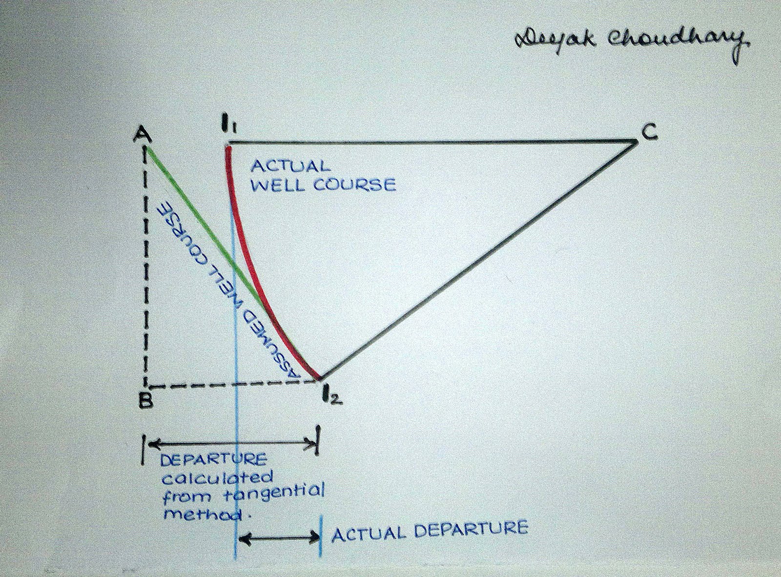
As shown in the figure below, I1I2 is the actual wellbore course. To calculate the inclination at I2, we draw a tangent to I2. The tangential method states that the tangent drawn at the survey station I2 is the assumed wellbore course and angle A is the required inclination which is similar to inclination at I2.
It uses only the inclination and direction angles measured at the lower end of the survey course length.
Now applying trigonometry to the right angle triangle ABI2, we have :
 |
| Directional Drilling : Tangential Method |
angle A = angle I2
AI2 = assumed well course = ΔMD (change in measured depth for this interval)
AB = AI2 Cos I2 = ΔTVD (This will be equal to the TVD for this interval)
BI2 = Departure
ΔNorth = ΔMD SinI2 x Cos A2 .
ΔEast = ΔMD SinI2 x Sin A2 .
It is clear from the above figure that the Tangential method gives a noticeable error in Measured Depth (MD) and Departure.
In Type I, III and IV holes, the error will be significant.
With the tangential method, the greater the build or drop rate, the greater the error. Also, the distance between surveys has an effect on the quantity of the error. If survey intervals were 10 feet or less, the error would be acceptable. The added expense of surveying every 10 feet prohibits using the tangential method for calculating the wellbore course especially when more accurate methods are available.
"With my study and practice works performed on live well data, I observed that the calculations based on Tangential Method gives a considerably large value of departure and in some cases the well appears to be too shallow. In some deviated wells, the error in TVD was more than 40-50 feet."
BALANCED TANGENTIAL METHOD
The balanced tangential method uses the inclination and direction angles at the top and bottom of the course length to tangentially balance the two sets of measured angles. This method combines the trigonometric functions to provide the average inclination and direction angles which are used in standard computational procedures.
 |
| Directional Drilling: Balanced Tangential Method |
From Balanced Tangential Method, following values are obtained:
ΔTVD = ΔMD/2 . (CosI1 + CosI2 )
ΔNorth = ΔMD/2 . [(SinI1 x CosA1) + (SinI2 x CosA1)]
ΔEast = ΔMD/2 . [(SinI1 x SinA1) + (SinI2 x SinA1)]
This technique provides a smoother curve which should more closely approximate the actual wellbore between surveys. The longer the distance between survey stations, the greater the possibility of error.
AVERAGE ANGLE METHOD
When using the average angle method, the inclination and azimuth at the lower and upper survey stations are mathematically averaged, and then the wellbore course is assumed to be tangential to the average inclination and azimuth.
 |
| Directional Drilling: Average Angle Method |
From Average Angle Method, following values are obtained:
ΔTVD = ΔMD . Cos(I1+I2)/2
ΔNorth = ΔMD . Sin(I1+I2)/2 . Cos(A1+A2)/2
ΔEast = ΔMD/2 . Sin(I1+I2)/2 . Sin(A1+A2)/2
Since the average angle method is both fairly accurate and easy to calculate, it is the method that can be used in the field if a programmable calculator or computer is not available. The error will be small and well within the accuracy needed in the field provided the distance between surveys is not too great.
RADIUS OF CURVATURE METHOD
The radius of curvature method is currently considered to be one of the most accurate methods available. The method assumes the wellbore course is a smooth curve between the upper and lower survey stations. The curvature of the arc is determined by the survey inclinations and azimuths at the upper and lower survey stations as shown in Figure below. The length of the arc between I1 and I2 is the measured depth between surveys.
 |
| Directional Drilling: Radius of Curvature Method |
ΔTVD = [(180) (ΔMD) (SinI2 – SinI1 )] / π (I2 - I1)
ΔNorth = [(180)2 (ΔMD) (CosI1 – CosI2) (SinA2 – SinA1) ] / π2 (I2 - I1) (A2 - A1)
ΔEast = [(180)2 (ΔMD) (CosI1 – CosI2) (CosA1 – CosA2) ] / π2 (I2 - I1) (A2 - A1)
DEP = [(180) (ΔMD) (CosI1 – CosI2 )] / π (I2 - I1)
r = 180 / π (DLS)
ΔMD = (I2 - I1) / Br .
Where,
π = 3.1415926
DLS = Dog Leg Severity
Br =Build Rate
Note: In these equations, the inclination and azimuth are in degrees.
Since the calculation using this method becomes a tedious job, this method is not used in field practise unless a programmed software is available based on this method.
I have hands-on experience on few well planning softwares based on this method. In the coming blogs, we will discuss on "Directional Well Planing" and for calculation purpose, I will show you that how these softwares are utilized to design a directional well.
Here, its worth mentioning that when the value of inclination (I) and azimuth (A) are same at both survey stations, then the denominator for some of the above equation becomes zero and hence the equation is not defined. This is the ERROR we found using "Radius of Curvature Method".
SO HOW CAN WE OVERCOME THIS ERROR ??
One of the way to overcome this error is to use "Minimum Curvature Method" which has been discussed below.
The second method i would suggest is that, we can add any small number (say 1 x 10⁻⁴ or 1 x 10⁻⁵) to either survey points. The result thus produced will be insignificant .. !
MINIMUM CURVATURE METHOD
No comments:
Post a Comment