Showing posts with label Inclination. Show all posts

Monday, February 1, 2016

20. KICK OFF PROCEDURE FOR DIRECTIONAL WELLS

Dedicated to : Mr. APS Gill, Mr. Munir Alam, Mr. S Suman & Mr. Chandrashekhar Mallik , Directional Drilling Team, ONGC Limited, Mehsana Asset, INDIA                       
----------------------------------------------------------------------------------------------

In directional wells we usually drill vertically upto the kick-off point (KOP).
From the KOP the well is deflected towards the target.
While planning a directional well we determine an angle and a direction in which the well is to be kicked off.

I hereby furnish my experience of kick off operation gained at a Horizontal directional well at Location No. :SNHK, drilled at Santhal Oil Field, Cambay Basin of Western Onshore, India.

Operator: Oil and Natural Gas Corporation Ltd., India
Directional Drilling Service Provider: M/s Weatherford Oil Tool Middle East Ltd.

Fig 20.1 General Well Data
 Note: The Excel sheet has been manually developed by Deepak Choudhary for Academic Purpose.

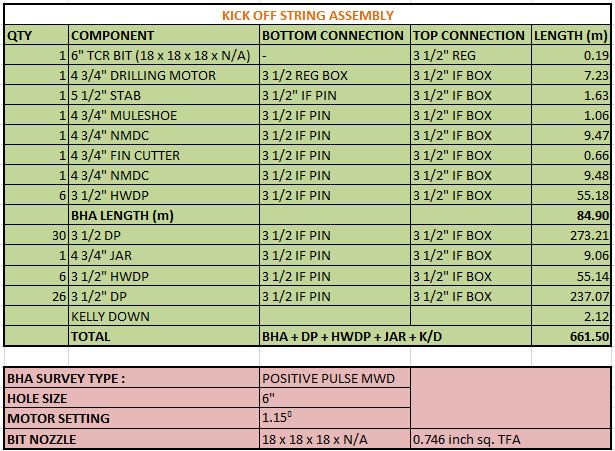
Fig 20.2 Kick off String Assembly
Note: The Excel sheet has been manually developed by Deepak Choudhary for Project Report Purpose.
 
Operation Report :

M/Arrangement & R/I with above BHA along with MWD tool assembly upto 661.50 m against planned 687.00 m. 
Circulated to condition mud at 661.5 m. 
Stopped circulation and conducted survey at bottom keeping the string in satic condition. 
The survey reading gives us the value of inclination, azimuth and toolface.
It should be noted that for angle less than 3 or 5 degree, the tool gives us MAGNETIC TOOL FACE.
These survey readings are displayed on the MWD Rig Floor Display Unit and looks like shown in figure below:


Fig 20.3 MTF indication at MWD Rig Floor Display Unit

Now after the survey is conducted, we observed that that MTF is 40 degree.
It is to be noted at the MTF and Azimuth are same, i.e. wrt true North. So by adjusting the MTF we can kick of the well at our required azimuth which is 189 degree.
So in order to bring MTF to 189 degree, the scribe line of the motor should be rotated by an angle of 149 degree (= 189 - 40)  towards right (clock-wise).

Once the required toolface setting has been determined (i.e. 149 degree), the effect of reactive torque must be considered.

Reactive torque is the twisting effect caused by the stator of the downhole motor turning anticlockwise in response to the rotor turning clockwise.

The amount of twisting depends on the physical properties of the motor, the length of the drill string and the formation characteristics. 

Motor manufacturers provide estimates of how much left-hand turn can be expected under certain situations. From these tables, or from experience of drilling with similar tools in similar formations, the directional driller must compensate for reactive torque by deliberately pointing the tool face to the right of the calculated heading.

As soon as the bit begins to drill, the scribe line will turn to the left to bring it
back to the calculated heading. The amount of WOB will also affect the reactive torque. As the bit drills off, the reactive torque will reduce.

In our case, the result of reactive torque was estimated to be about 20 degree.

So, net right turn to be provided = MTF Correction (149)+Reactive torque (20) 

Thus to make a 149 degree incriment in MTF, we need to rotate the whole system by 169 degree right (i.e. clockwise).

Now we take into consideration the Bit walk. Bit walk is the tendency of the bit to wander off course by following the direction of rotation (usually to the right). 
Let us consider 10 degree as a correction factor to maintain the deviation tendency due to bit walk.
So now from 169 degree we have to reduce 10 degree to adjust the bit walk tendency.

Finally, we are left with 159 degree.

To do so, we make a reference marking on rotary table and other marking which is 159 degree to right of rotory table marking on the floor using chalk.
Note: the two markings should be visible to the driller as he is the one who is going to rotate the rotary table.

The marking made on the rotary table is as shown in the picture below :

Fig 20.4 Tool face Correction
 Now, by rotating the rotary table in clock wise fashion, we will coincide the two markings so that the whole system rotates by 159 degree right.
After the two markings coincide, it looks something like as shown in the figure below :
Fig 20.5 Tool face Correction
 After the markings coincide, we look at the MWD Rig Floor Display unit which keeps updating the tool face every 30 seconds.

Now the situation is that, the string is stationary and we are waiting for the tool face to be updated on Rig floor display unit.

We want the rig floor display unit to show the MTF to be equal to 179 degree exact wrt North (N). 
It is to be noted that the reactive torque may vary. The data provided my Mud motor manufacturers and the estimate made by the directional driller are not always an exact data. It's an estimated one. So there might be some positive or negative error in the MTF reading which we are waiting for.

So the wait is over ... Here comes the updated tool face reading :

Fig 20.6 MWD Rig Floor Display Unit showing the corrected MTF
The actual reading of 175 degree is practically obtained which is 4 degree less than the desired 179 degree.

We have a scope to correct this 4 degree difference in azimuth over the remaining course length. Therefore this difference of azimuth is not a harmful issue. It is suggested that there is no harm if kick off is performed at 175 degree azimuth and later correction may suitably be made for the said 4 degree.

KICK OFF TECHNIQUE

Now to kick off the well with azimuth = 175 degree, we lock the rotary table so that there is no rotational movement provided to the drill string which may disturb its tool face orientation.
The drilling is now performed by the mud motor, not by the kelly. At the derrick floor the whole system is stationary and the mud motor performs its drilling job at the bottom.
From the surface we continuously keep maintaining the desired WOB so that the further drilling by mud motor is continued. This process of drilling using mud motor by keeping the rotary table in locked condition is called SLIDING.

During kick off, our main motive is to initially provide a guided path to the BHA. Now what length to slide will depend on the type of formation being drilled.
In prevailing practice, slide in one stretch is done for 10-12m of MD. The decision of the length to be slided depends upon the consolidation of the formation being drilled. 
In loose formation there is more risk of deviation, so the slide length is taken more than 2 drill pipe length. 
In hard formation the deviation tendency is less, so even a single drill pipe length of slide is sufficient to guide the bit in a particular path.

The kick off operation is now over.

Based on his experience, the Directional Driller will decide to take further sliding or to switch over to rotary drilling.

Fig 20.7 Sliding using Mud Motor (Left) and Rotary Drilling (Right)
Now our next objective is to check the result of our slide. It is to be noted that the MWD tool lies at about 20 m above the bit. This distance b/w the MWD tool and the Bit is called the tool offset. After we have slided for say 12 m, the drilled depth is 661.5+12 =673.5 m. The position of bit is now at 673.5 m and the MWD tool is 20 m above the bit, i.e. at 653.5 m.
When the drilled depth will be 673.5+20=693.5 m, the position of MWD tool will be at the end of slide, i.e., at 673.5 m.

Now we can take survey to check the result of our sliding action.

Survey Procedure :
- Stop Rotary.
- Bring String 3-4 m off bottom.
- Circulate out cuttings.
- Shut off pump and confirm that Pump Down Time at MWD Rig Floor Display  unit declines to zero. It indicates that the pump discharge is zero.
- Now concentrate at Pump Up Time at MWD Rig Floor Display unit. It keeps on increasing which indicates the time for which the pump had been kept shut off (no discharge observed). 
- It is worth mentioning that it takes about 2 -3 minutes for the display of survey data at MWD Rig Floor Display unit.
- Record the Survey data.

The case data is furnished as below :
Fig 20.6 Survey Sheet
Note: The Excel sheet has been manually developed by Deepak Choudhary for Project Report Purpose.

In the table, the survey readings at 693.15 m MD is the result of 12 m slide. This also indicates that the slide was properly performed and has given the desired result.


END OF THE BLOG


19. Toolface : Magnetic Tool Face (MTF) , Gravity Tool Face (GTF) , Tool Face Orientation

The sensors used in steering tools and MWD/LWD tools are solid-state electronic devices known as magnetometers and accelerometers which respond to the earth's magnetic field and gravitational field respectively.
 
Since the magnetometers may be affected by the steel collars and drill pipe, the probe must be seated within non-magnetic collars. The probe slots into the muleshoe key, which is aligned with the scribe line of the bent sub. 

The probe therefore measures the direction in which the scribe line of bent sub is pointing.
 
The orientation of the bent sub can be measured relative to Magnetic North (magnetic toolface) or with respect to the High Side of the hole (gravity toolface). 

If we place a plumb bob at the centre of any section of wellbore, the plumb bob orients itself in the direction of "g", vertically downwards. The direction opposite to the orientation of plumb bob is the high side of the wellbore.

At low inclinations (0-5°) magnetic toolface is used, since the High Side is not well-defined at that stage. Once the angle increases, however, and the hole direction becomes established, the gravity toolface is used (i.e. toolface is reported as a number of degrees to the left or right of High Side). 

The High Side of the hole can be defined by the accelerometers. The High Side is directly opposite to the gravity vector, which is the sum of the three gravitational components measured by the accelerometers.
 
Now, before taking this discussion ahead, you should know what scribe line and  the tool face alignment and orientation  means.

Look at the figure below. It shows an adjustable bent sub which gives us an option to adjust the amount of bent we wish to provide to the motor. It generally ranges between 0 to 3 degrees.


Now to provide a desired bent, we hold the upper and lower ABH (Adjustable Bent Housing) using the tong and by using chain tong on orientation sleeve we coincide the upper and lower angular marking to the desired value.

 
Suppose we desire to provide 2.89 degree initial bent. So after coinciding the two angular marking, what the bent sub looks is like in the figure below :


The line passing through the two coincident angular markings give us bent sub tool face, i.e. the orientation of our bent sub. See figure below :


Now have a look at this figure:
This is how the accelerometer and the magnetometer is arranged in the MWD unit aligned  in same axis (z axis).


Typically, three magnetometers and three accelerometers are used to measure the three components of the gravity vector and the Earth magnetic field vector in the sensor frame.

The voltage outputs from the accelerometers are denoted by Gx, Gy and Gz, corresponding to the three orthogonal axes.

Similarly the magnetometer outputs are Hx, Hy and Hz.

z axis points down the axis of the tool and the y axis is defined as being in line with the toolface.

Now in order to accomplish the directional drilling task, the operator needs to know the orientation of the bent sub. The relationship between the directional sensor and the bent sub is fixed for each bottom hole assembly. From the directional sensor measurement, the directional sensor tool face is known. If the angular difference between the directional sensor reference point and the bent sub is measured on the surface, then the operator can use this measurement and the directional sensor tool face reading to determine the orientation of the bent sub, namely, the bent sub tool face. Such angular difference is sometimes called tool face offset.

In the prior art, the angular difference is determined by the use of a scribe line on the exterior of the instrument housing.

Now our next job is orient our MWD/LWD tool in the direction of bent.

Below is a typical BHA arrangement for a 8 1/2" Hole Section :


After we are done with adjusting the bent sub to a desired angle, we make up the string stabilizer, the float sub, the UBHO sub and 1 (one in number) NMDC (also called Monel). To know more about Stabilizer, Float Sub and UBHO sub refer my blog post : Stabilizer, Float Sub , UBHO Sub. 

Now out job is to lower the MWD tool assembly into the NMDC. 

The MWD tool is run inside the NMDC (Monel).

It gets seated in the mule shoe sub (UBHO Sub) which is at the bottom of NMDC.

The tool face of MWD usually doesnot remain aligned with the toolface of downhole motor.

So as to align the MWD toolface with the toolface of downhole mud motor we practise any one of the following procedure :

1
In this procedure, we get back to the time when we have made up the UBHO sub and the MWD tool has not yet been lowered.
 
The mule shoe sub has an adjustable key.

The sleeve with the key can be rotated.

The set screw is loosened and the key is alligned with the bent of the downhole mud motor.

Once the key is aligned with the bent of the motor, the set screw is tightened.

This keeps the key always aligned with the bend provided to the motor.

Now the orientation of mule shoe is same as that of the motor bend.

The MWD tool is run into the NMDC.

The tool has a mule shoe stinger on it.

The stinger has a slot and the mule shoe sleeve has a key.

When the mule shoe stinger enters the mule shoe sub, it is rotated until it gets lined up with the orientation of the mule shoe sub and the motor.
This happens when the slot of the stinger gets seated in key of the UBHO sub.

Note : The survey tool can easily be manually rotated until the tool is aligned with the key.

Thus now the tool face shown by the MWD tool is also the tool face of the bend of the down hole motor.
UBHO Sub


2
In this procedure, we are at the situation when we have lowered the MWD tool in the NMDC and the stinger's slot has got seated in the UBHO sleeve's key.
 
The scribe line at the mule shoe key indicates the tool face of the MWD tool.
The scribe line at bend of the downhole motor indicates the toolface of the bent of the motor.

Now we check that the two scribe lines (one of the motor and other of the surveying tool i.e. MWD here) are aligned or not.

At present condition, we have the following arrangement hanging fron the elevator from top to bottom: NMDC - UBHO Sub - String Stab - Mud Motor - Bit.
We lower the present made assembly until UBHO Sub is on man height.

At the key of the UBHO sub (i.e. on the scribe line), we make any marking like placing a chalk piece or any pointed visible object which shows us the position of the scribe line/ the UBHO key. Some people tape a laser pointing downwards.

Now we lift the made assembly upwards using elevator until we have our bent sub at the man height.

We apply slip to make the assembly stationary.

Now we look up at our placed marking on the UBHO sub and find its position relative to the bend sub scribe line. (For this, the operator stands closer to the bent sub, looks upward to the made marking and tries to make an imaginary line from the marking to the bent.

If the two scribe lines are aligned, then no issues. We are done with our job.

But, if the two scribe lines are not alligned, then we measure the offset tool face (OTF) between the two scribe lines using the protector, which gives and angular value of the offset.

This offset tool face (OTF) is a correction factor.

Now, the operator must decide whether to add or subtract this angular difference to the directional sensor tool face for purposes of determining the orientation of the bent sub. Obviously, the decision as to whether to add or subtract the angular difference is critical. Operators are trained to follow a procedure to correctly determine whether the angular difference should be input into the surface computer as a positive or negative number to be added to the tool face reading to obtain the bent sub orientation. 

Refer figure below which clearly describes the above procedure : 
  
 Geometrically, we can explain the offset angle as shown in figure below :


CORRECTIONS
Offset Correction aligns accelerometer toolface with toolface of bent sub.
Magnetic Declination correction corrects the magnetometer error.

In the picture below, I have tried to explain how the axis of the accelerometer actually behaves and helps determining the inclination, using the help of a hand made rough model.


INCLINATION
The inclination is the angle measured from vertical to the axis of the Z accelerometer.
The inclination can be determined from the above model and comes out to be :

tan α  = ( Gx2 + Gy2 )1/2 / Gz .


TOOLFACE 

Magnetic Tool Face
It is the direction, in the horizontal plane, the bent sub scribe line is pointing with regard to the north reference (Grid, Mag, or True). 

Magnetic orientation is used when the inclination of the well bore is less than 5°. When the inclination is below this amount, the survey instrument cannot accurately determine the highside of the instrument for orientation purposes. The toolface will be presented in azimuth or quadrant form, referenced to magnetic north. The magnetic toolface reading is whatever magnetic direction the toolface is pointed. 

Gravity Tool Face
It is the angular distance that a bent sub scribe line is turned, about the tool axis, relative to the high side of the hole. 

If the inclination of the well bore is above 5° to 8°, then the gravity toolface can be used. 
The toolface will be referenced to the highside of the survey instrument, no matter what the hole direction of the survey instrument is at the time. 
The toolface will be presented in a number of degrees either right or left of the highside. 

GTF orientation is represented by figure below :

BLOG ENDS

Directional Drilling Terminologies

AZIMUTH


There are three azimuth reference systems: True (Geographic North), Grid North and Magnetic North.

Geographic North: In geographic coordinates directions are referred to true north, or a true azimuth. Geographic north points to the North Pole; this direction is indicated by the polar star.

Grid North: Grid north is an arbitrary direction and is always in the direction of the positive ordinate axis of the specific grid used for a particular survey.

Magnetic North: Magnetic north can be measured by a simple magnetic compass. Magnetic azimuths are not constant due to the movement of the north and south magnetic poles and hence magnetic measurements may be in error due to local magnetic field variations. 

In oil wells, all surveys with ‘magnetic type’ tools are initially given an azimuth reading referenced to Magnetic North. However, the final calculated coordinates are always converted to either True North or Grid North.

Magnetic Declination: Magnetic north and true north do not coincide. The divergence between true north and magnetic north is different for most points on the earth’s surface, and in addition to this the magnetic north pole changes its position very slightly each year.
The angle in degrees between true and magnetic north is called the declination angle. The declination angle is negative if magnetic north lies to the west of true north and is positive if the magnetic north lies to the east of true north (refer figure below).


The azimuth of a wellbore at any point is defined as the direction of the wellbore on a horizontal plane measured clockwise form a north reference. Azimuths are usually expressed in angles from 0-360 , measured from zero north.
Note: West Declination is always Subtracted and East Declination is always Added. i.e., TRUE NORTH = MAGNETIC NORTH ± (DECLINATION)
Azimuth on horizontal plane, 20 degrees wrt True North
Azimuths can also be expressed in a quadrant system from 0-90 measured from north in the northern quadrants and from south in the southern quadrants.
The figure above shows azimuth reading of 135 equates to S45 E in quadrant readings.
Measured in: degree 

INCLINATION

The angle of the well bore defined by a tangent line at any point of wellbore and a vertical line is called the inclination. The vertical line is always parallel to the direction of earth's gravity. By industry standard, 0 degree inclination is vertical (downward pointing) and 90 degrees inclination is horizontal. An inclination (angle) greater than 90 degrees coincides with the term "drilling up".
Measured in: degree 


NOTE: AZIMUTH & INCLINATION ARE ALSO TERMED AS DIRECTION AND ANGLE RESPECTIVELY.

MEASERED DEPTH (MD) & TRUE VERTICAL DEPTH (TVD)

Measured Depth (MD): Measured depth (MD) is the distance measured along the well path from one reference point to the survey point.
Measured in: Feet (ft) or metre (m)

True Vertical Depth: The vertical distance from a point in the well (usually the current or final depth) to a point at the surface, usually the elevation of the rotary kelly bushing (RKB) is called the true vertical depth (TVD) at that point.
Measured in: Feet (ft) or metre (m)

It is to be noted that MD ≥ TVD in all cases.


VERTICAL SECTION (VS)

A projection of the borehole into a vertical plane parallel to the course bearing and scaled with vertical depth.

KICK OFF POINT (KOP), BUILD, HOLD & DROP

Kick off Point (KOP): The kick off point is defined as the point below the surface location from where the well is deflected from the vertical. The position of the kick off depends on several parameters including: geological considerations, geometry of well and proximity of other wells.

Build Up: It is the act of increasing the inclination of the drilled hole wrt vertical.

Build Section: That portion of the hole in which the inclination angle is increased; rate of buildup is usually expressed as the angular increase per 100 feet of measured depth.

Build Up Rate (BUR): It is the rate of change (degrees/100 feet or degrees/30 metre) of the increasing angle in the hole.

Drop off: It is the act of reducing the inclination of the drilled hole wrt vertical.

Drop Section: That portion of the hole in which the inclination angle is decreased; rate of drop off is usually expressed as the angular increase per 100 feet of measured depth.

Drop off Rate: The rate of change of the inclination in the part of the wellbore where the inclination angle is purposely returned toward vertical, usually expressed in degrees per feet or course length.

Hold: The act of maintaining the inclination and azimuth of the wellbore to remain constant as it is.

Tangent or Hold Section: The portion of hole in which the inclination and azimuth is maintained the same throughout the section.

In the figure below, KB means Kelly Bushing, RT means Rotary Table, DF means Derrick Floor, EOB is for End of Build (i.e., the point at which the Building ends and we either hold or drop the wellbore path).


RECTANGULAR COORDINATES


Rectangular coordinates of a target are usually given in feet/meters North/South and East/West of the local reference point. They can be easily derived by subtracting the grid coordinates of the surface location from those of the target.
The rectangular coordinates can be used to calculate the departure (horizontal displacement) between the surface location and the bottom hole target as follows:
Departure = [(Δ E/W)2+ (Δ N/S2)]1/2
where: Δ denotes difference in coordinates between E/W or N/S 
 
POLAR COORDINATES

Polar coordinates can be derived from the rectangular coordinates. They are expressed as a distance (departure) and as a direction (either Quadrant or azimuth). 
Polar coordinates are derived from the rectangular coordinates as follows:
Azimuth = tan-1 ((Δ E/W Coordinates)/( Δ N/S Coordinates))

Now let us try to solve a problem based on the above concept of Rectangular and Polar coordinates.
We have been provided the grid coordinates of the surface and target location. We need to find the Departure and Azimuth of the target from the surface location.  
Grid Coordinates: Target   6,334,400.00 N (m)      200,600.00 E (m)
Grid Coordinates: Surface 6,335,000.00 N (m)      200,400.00 E (m)
 
Now let us calculate the rectangular coordinates.
Δ N/S = N/S (target) - N/S (surface) = 6,334,400.00 - 6,335,000.00 = -600 m
Δ E/W = E/W (target) - E/W (surface) = 200,600.00 - 200,400.00 = 200 m

Now, Azimuth = tan-1 ((Δ E/W Coordinates)/( Δ N/S Coordinates))
thus, Azm = tan-1 (200/-600) = -18.4 degree

Also, Departure = [(Δ E/W)2+ (Δ N/S2)]1/2
thus, Departure = [(200)2+ (-600)2)]1/2 = 632.5 m

Hence in polar coordinates, the target is 632.5 m at an azimuth of 161.6 degree (S18.4W).These coordinates are plotted in figure below: